~Tad Jones


Adventure Journal and Photography

We ran the Sawtooth Relay this weekend and had a great time. The name of our team was “More Cowbell” and we were team #234
The Sawtooth Relay is a 62 mile run and is separated into twelve legs. Teams of six individuals run from Stanley, Idaho to Ketchum Idaho over the famed Galena Summit. The proceeds for the race are all donated to the PKD Foundation and are used for research in finding a cure for kidney disease. Our team this year consisted of Trent & Shelly Koci, B and Tamara Clayton, and Karma and me. Each team is required to have one volunteer for the race and Tim Terry generously served as our volunteer. Zoie came along with us too and Karma’s Mom Dorothy watched her while we ran the race. We stayed in Ketchum on Friday night and then woke up around 1:30 in the morning. We picked up B and Tamara around 2:00am to drive to Stanley for a 4:00am start. The race was a bit rainy this year, but we still had a blast! We finished the race at around 1:00 in the afternoon with a total time of just over 9 hours.
Sawtooth RelayI ran the Race to Robie Creek today. I did much better than I had expected with a finishing time of 1:57:23.392 which put me in place number 331. The race starts at Fort Boise and winds up Shaw Mountain Road. Near the top of Shaw Mountain Road the course heads up the old toll road at Rocky Canyon and over Aldape Summit. After passing over the summit the course takes a steep descent down into the Robie Creek drainage and ends with a spectacular party at a large park on the shores of Mores Creek.

The Race to Robie Creek is called “The Toughest Half-Marathon in the Northwest.” The race raises over $45,000 for local charities and non-profit organizations. There were over 2,400 runners in the race this year.
Click here to visit the website for the Race to Robie Creek.
Karma and I went dirtbiking today up near Bogus Basin. We traveled on old logging and mining roads. I put together a little video of the trip. In the video I used a font that reminded me of the 1980’s when I would ride for miles & miles on my Grandpa’s old Honda 90. The music is by “They Might Be Giants” called “Dirtbike”…..I love the lyrics in this song. Thanks Joe!
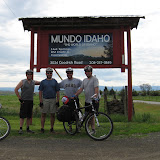 |
| Weiser River Trail | 2009 |
 |
| Photos by Tucker Anderson |
We rode the Weiser River Trail this weekend from Evergreen Campground to Galloway Dam near Weiser, Idaho. Karma was our shuttle driver and brought BoBeau and Hank along to keep her company on the drive home.
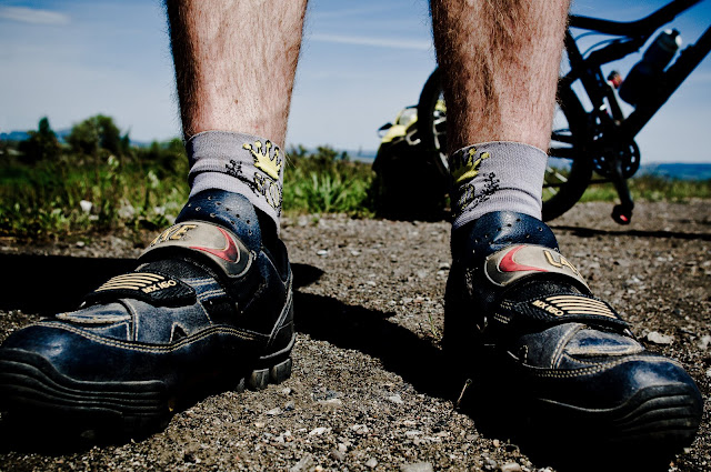
The riding crew consisted of Jay Stevenor, Tucker Anderson, and I. Clancy brought his Xtra Cycle, Tucker used panniers mounted to a bike rack, and Jay and I towed trailers. I was towing a TW Bents trailer and Jay was trying out a Bob trailer with suspension.
The total mileage for the trip was 71.41 miles according to the GPS. We stayed at an underdeveloped (primitive) campground on the river called Mundo, which is just outside of Cambridge, Idaho.
The upper section of the trail is in a wooded alpine setting and as the trail loses elevation the scenery turns to a high mountain valley ecosystem and finally ends in a grassy desert setting.
Along the way we encountered historic buildings, wildlife, cattle, and a huge herd of goats being herded by working dogs and shepherds.
It was an amazing trip with good riding, scenery and best of all great friends!
~Tad Jones


The drive into Leslie Gulch can be quite an epic adventure. The road down in the gulch is a well maintained gravel road, but up on the flat area above the gulch there are many different undeveloped tracks. Upon coming out of the gulch , I met a guy in a pickup with a camper that had been lost for 2 days. I gave him directions back to the highway.

Many of the rock formations seem ready to separate from the high cliffs above at any moment and tumble down to the valley floor.

This rock wall looks as if many stone faces have been cast into the rock. While hiking by this formation I had the eerie feeling that I was being watched by thousands of eyes. The formations were actually formed by pockets of gas developing in rhyolite deposits from the Mahogany Mountain /Leslie Gulch ash flow tuft.

This rock wall looks as if many stone faces have been cast into the rock. While hiking by this formation I had the eerie feeling that I was being watched by thousands of eyes.

Bobeu and Hank and I headed up the Juniper Gulch trail. The trail is basically a wash, so I was very aware that I was in flash flood territory. The dark rain clouds and high humidity were also good indicators to the potential for flash flooding.

Among the other amazing and extraordinary formations I found this huge cave. The cave may be a good place to spend the night if there wasn’t any wind blowing into the opening. I would later find some deeper caves.

Another balanced rock. This one extending above an area of faces cast in stone.

Bobeau and Hank have a good time hiking in this area. They are very calm and follow me and stay on the trail the entire hike. They are very well behaved.

This rock reminds me of some kind of mushroom. The formations are very interesting when analyzed in detail. The combination of wind and water has further sculpted the original gas bubble formations over the years in the soft malleable rhyolite.

This rock is about the size of a dinosaur egg. I can imagine a prehistoric animal emerging from the rock. I can easily stand inside the rock as I pass by it on my hike.

Weather is starting to set in. It is starting to drizzle and the wind is really picking up.

The Leslie Gulch area is a great place to let your imagination run wild! There are so many odd formations and so many stimuli to imagine familiar objects in the stone. Here is an eagle perched on top of a large stone mass. Behind him is an alien form. Leslie Gulch is a lush garden for the imagination that spawns natural visions of the extraordinary.

These stone pillars rise vertically from the valley floor below. This could be a climber’s dream if they enjoyed chimney stemming. From a distance this formation looks like a throne for a giant.

The course of water can be seen in this gully reminding me of the bobsled tracks used in Olympic competition.

This cave was on the outside corner of the wash. I belive a gas bubble created the cave and then water has increased its depth over the years. Water erosion has carved out the cavern under the overhanging cliffs as it continually rounds the corner and centripetal force causes a scouring of the soft rhyolite.

Still inside the wash. This wall has held up against the erosion

The berries are know for use in flavoring Gin. They were also traditionally used as a spice in European cuisine. Not an actual berry, they are the female conifer seed cone of the juniper tree. Some species (Juniperus Sabina) are poisonous. This photo most resembles Juniperus Californica (California Juniper) or possibly Juniperus Osteosperma (Utah Juniper).

This is a small cabin on the way out of Leslie Gulch.
~Tad Jones

Karma and I rode our dirtbikes into Loon Lake this weekend. I hadn't been in there since I was a kid & it had changed quite a bit. The fires of 2007 took a major toll on the landscape and it was surreal riding between burned snags and downed timber. On the way in we saw five airplanes following eachother. The cloud cover was very low and I think they were working together to get out of the area to find a safe place to land. We went on a "pre-ride" the day before to get used to the trails being a bit more technical than they are around Boise. Here are some photos of the trips.

Karma getting ready for the ride.

We rode up to Picnic Point the first day. While we were up there the sun came out and a super bright rainbow appeared above Payette Lake. It was just starting to fade by the time I snapped this photo.

We rode in through Ruby Meadows and the trail has changed a lot since I was younger. We stopped at the intersection with the trail coming from Chinook Campground. There is a new bridge going over to the Victor Cr. trail & I had remembered a small cabin at this site before.


We made it to the lake. We left the bikes at the camping area and hiked down to the lake so that we wouldn't disturb anyone if they were down at the lake. It was really foggy and Enos Peak was obscured by clouds. The entire ride in reminded me of photos I have seen of tropical rainforests in South America with the clouds hanging on the tops of the mountains. We could see pieces of the airplane on the other end of the lake from this vantage point. We opted not to go around the lake, partially because the weather was deteriorating, & the last time I had visited the lake many parts of the plane had been scavanged & I would rather remember the site from when I was young. I used to come up to this lake by myself quite a bit when I was younger and camp at the inlet. I also spent some time with Tucker Anderson up at the lake. I remember both of us drinking out of the inlet & Tucker getting giardia later in the week. I also spent a lot of time up at the lake with my Dad fishing and camping. My Mom & Doug & Gusti & Andy Laidlaw & I were some of the first people to mountain bike into the lake. It was when mountian bikes were just being introduced into the area & we were exploring a lot of the hiking trails on mountain bikes.

This trip was great because we got to share it together. Karma thought she had been to the lake with me due to the many stories I have told her about it in the years we have been together. While riding up the trail she realized we had never actually been there together until now. It was an amazing day!
~Tad Jones
Karma and I went camping this Fourth of July weekend with some of our friends. We stayed at a spot along the South Fork of the Payette on the road up to Grandjean. On Saturday morning after a lot of coffee to get motivated we drove up to the trailhead at the Grandjean campground. We hiked towards Baron Lakes. Our friends Lee and Abby hiked with us for a couple miles and then turned back. They took Bobeau back with them since he was getting pretty tired and Karma and I were planning a big day ahead of us. Lee and Abby planned on taking Bobeau with them to Bull Trout Lake to go kayaking on the lake. Clancy and Anne were going to meet up with them and go to Bull Trout lake as well. Hank came with us and did really well. We saw a few horses coming down out of the mountains and a couple other hiking parties, but it felt very secluded. We turned East at the confluence of Baron Cr. and the South Fork of the Payette and headed up the wide canyon. Grandjean peak was to our South and there was still snow tucked away in the small areas that were hidden from the sun.


We saw lots of waterfalls cascading down the cliffs above us. We reached the North Fork of Baron Creek and found it a torrent of water. We searched downstream and found a large log to cross the Creek.


Our next water crossing was at Moolack Creek. We found a log upstream of the trail at this crossing.

The trail was covered in thick brush and we were glad that we had worn long pants for the treck. The temperature was a little on the warm side for long pants, but the protection they provided was well worth it.

We found a large tree with some shade and sat down to eat some Gorp and the first our Sandwiches. It was a good break. The only sounds around us were the sounds of birds and water rushing down the mountains. The wildflowers were amazing this time of year. I took photos of many of them that I didn’t recognize and some that I did such as Sego Lilies and Indian Paintbrush.


I will try to find the names out of some of the others later. On the way up we could hear woodpeckers pounding away at the surrounding timber. We also saw many trees perforated by their work. It took us about 5 hours to get to the waterfall and it was amazingly loud as we got closer to it. Huge amounts of water were tumbling off the mountains.

We discussed going up to the lakes, but felt a bit exhausted and we were running later than we had planned so we turned around about 7,600 feet in elevation. It looked as if we were about level with the top of the waterfall and after examining the topo map I confirmed our elevation with my watch and GPS and figured we had another 2mi to the lakes. On the way back I pumped purified water into our hydration packs from Baron Creek. We had really gone through a lot of water. We ate the last of our peanut butter sandwiches and almost finished the Gorp. The views in every direction were just awesome! It reminded me of the time I had spent in the Sawtooths with Grandaddy and my Mom and Dad when I was a little kid.


The trek out took us almost 4 hours so we ended up hiking for almost 9 hours straight. Our feet and legs took a bit of a beating between sore muscles and blisters. We stopped at Sacajawea hot springs on the way back to camp to rinse off. We got back into camp around 9:00 at night and made a steak dinner. After dinner we hung around the fire with friends until we couldn’t keep our eyes open any longer. We slept outside under the stars and woke in the morning to a squirrel running over our sleeping bags. What a great weekend!


